by Nick Engerer at Solcast
Previously, pages have covered the basis of solar geometry, and the general properties of solar radiance, including its measurement at the surface. However, given the relatively limited number of surface radiance measurement stations, compared to the total surface area of the Earth, other methods for estimating solar radiance over time have been developed through the advent of modern weather satellite technologies.
The modern methods for estimating solar radiance from geostationary weather satellites consists of four major steps. First, is the detection of cloud cover. Second is the characterization of that cloud cover in terms of its impact on solar radiance. Third is modeling the available solar radiance under clear skies. And fourth is the final estimate of the amount of solar irradiance reaching the Earth’s surface after it passes through the clouds (if any are present).
Step 1: Detecting Cloud Cover with Albedo
The core technology used for detecting clouds from space, is the imagery produced by satellites at 36,000 km (22,000 mi) above the Earth’s surface in geostationary orbits (meaning they are stationary relative to the Earth's surface). The latest generation satellites produce full-disk scans of the Earth every 10-15 minutes at resolutions as fine as 500 m. Imagers are recorded in several wavelengths of visible light, as well as many infrared wavelengths.
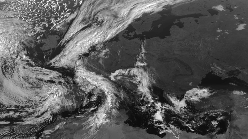
The above raw image from the satellite includes both land and ocean surfaces, as well as cloud features. Upon closer inspection, there are also regions of very bright land surfaces such as sands and also snow cover. In order to separate the land surface information and the cloud cover features, an estimate of the ‘albedo’ or appearance of the background when no clouds are present, needs to be calculated.
Albedo estimates are created by scanning satellite images from the recent history, which do not have any cloud cover present, to store in memory, what the surface should look like without any clouds. A deviation from this expected appearance will then reveal the location of a cloud. In the figure below you can review an example albedo calculation. Importantly, you’ll note the presence of snow cover in various locations on the map, as well as some areas of bright sands in Northern Africa. Without an appropriate albedo calculation, these features could easily be miscategorised as cloud cover.

Step 2: Characterizing Cloud Cover via Cloud Opacity
Once the albedo calculation has been applied to the raw visible imagery to, the next step is make an estimate of the thickness of the cloud cover that is present to solar radiance. The opaqueness of a given cloud cover feature to solar radiance is termed by Solcast to be ‘cloud opacity’. Cloud opacity is calculated in a variety of ways, some of which are proprietary and not documented publicly. However, most, if not all, will use the difference between the raw visible imagery and calculated albedo as the principle input to estimating cloud opacity. These and the formulae for estimating the relationships between cloud opacity and solar radiance are then calibrated using surface solar measurements from pyranometers located in the satellite coverage region. An example of the cloud opacity estimate from our original satellite image in the first image, is presented below.

Step 3: Estimating Solar Radiance with a Clear-Sky Model
There is one additional step to estimating the solar radiance that reaches the Earth’s surface, and that is to apply the estimated cloud opacity value to an expectation of how much solar radiance would be available under clear sky conditions. This is best thought of as the amount of sunlight that would reach the Earth’s surface if there were no clouds in the way. The scientific literature has a rich trove models for computing clear-sky radiance, with a wide variety of models which use varying data inputs such as the REST2 model1. Generally speaking these models rely on a handful of input variables to be computed:
- Solar geometry. The more overhead the sun is, the more solar radiation a given patch of the surface gets.
- Earth/Sun distance. There is a few percent variation in sunlight reaching the earth as its elliptical orbit takes it further and closer to the sun.
- Aerosols/Turbidity: Air is not 100% transparent, and water vapor and other aerosols attenuate some of the solar radiation that would reach the surface if there weren't an atmosphere in the way.
Step 4: Satellite Derived Solar Radiance
Once the clear-sky radiance has been accurately estimated through a clear-sky radiance model, a simple conversion is applied using the estimated cloud opacity values from the prior steps to generate a spatially continuous estimate of the availability of solar radiance at each location covered by the geostationary weather satellite imagery.
This calculation can be completed as follows:
$$ E=E_{clearsky} \times \frac{100 - \alpha}{100} $$
Where E is the solar radiance (global horizontal) and α is the cloud opacity (from 0 - 100).
The end result, which is an estimate of the solar radiance over the entire region of the original satellite image is presented below.

- 1. «REST2: High-performance solar radiation model for cloudless-sky irradiance, illuminance, and photosynthetically active radiation – Validation with a benchmark dataset», Solar Energy, vol. 82, n.º 3, pp. 272 - 285, 2008.